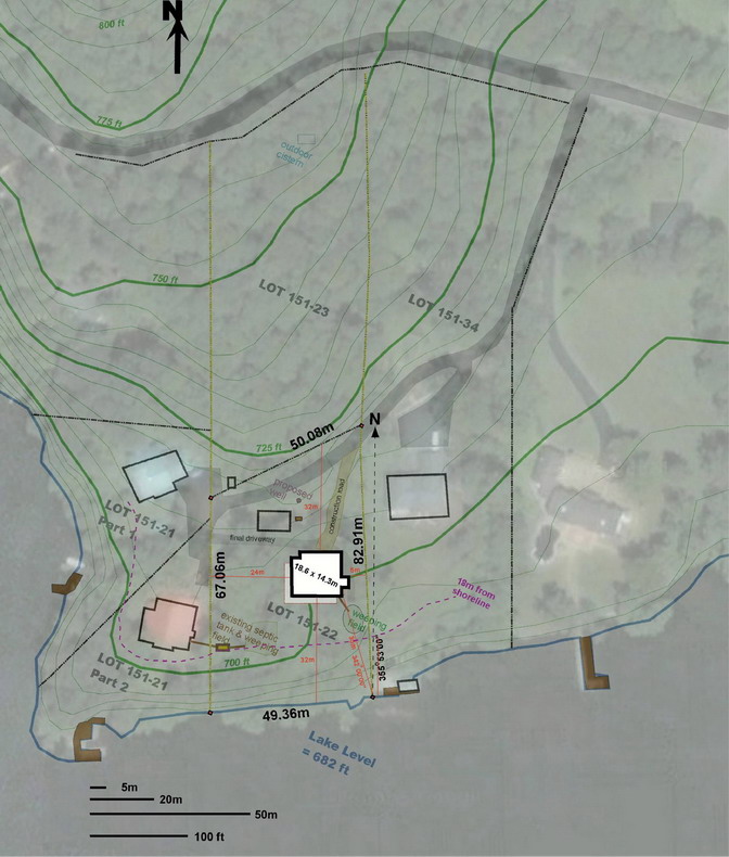
The building site is on lot 151-22 in the municipality of Ogden in the vicinity of Cedarville, approximately 300m west of Weir Memorial Park. The lot is an uneven polygon, very roughly 70m by 50m in size (0.3687 ha) with its long axis running north-south. The lot is on the shores of Lake Memphremagog and has an undisturbed* shoreline of approximately 49.4m. The lot has not been occupied since 1943, but a garage/boat shed was built on the property in 1974 close to the northwest corner of the lot. This building still exists. Topographic contours run approximately east-west and delineate a two-step profile to the lot, with a plateau extending from about 10m to 44m away from the shoreline, before rising steeply to the north. This flat area once held an old house and barn from the 1870’s. In particular the stone foundation of the old house was established as the southern- most boundary for our new house, as we wished to preserve the old foundation (and its trees) for nostalgic, aesthetic and environmental reasons.

Satellite image with lot lines and other dimensions
Prior to construction, Lot 151-22 was heavily treed with perhaps 25% open space occupied by an entry road, a shed and a small grassy area.
The land continues to rise to the north onto Lot 151-23, to a maximum elevation on this property of 83 feet above lake level. We plan to take advantage of this elevation gain for our water supply (see section on Water).
* The only man-made structure along this shoreline is a decaying cedar retaining wall built by my father in the 1970’s.
